Thursday, January 7, 2016

Tips for Back-country Adventure

Hidden Lake, Glacier National Park 
I had promised a Facebook friend some tips about back-country hiking in Glacier and thought that such tips might be helpful to others as well.  I need to make a couple of notes before I get started. Firstly, I have a lot of experience in the back-country.  Beginning in my early teens I started running with a group whose idea of a great weekend was to see how far or how long we could go taking as little as possible. This is the group of which I spoke in my Nov 2015 blog entitled Looking Out the Window (1) where we went canoeing down French Creek, through the Allegheny Mountains on a snowy November day.  A lot of people call such skills "survival skills" but most of these skills are really just skills you need to have a really great and fun time in the wilderness. So let's call them 'back-country skills'.  In any case, I have a lot of experience and fairly good skills but I still do not consider myself an expert.  If you go looking for a book about back-country skills, of which I'm sure there are many, be sure the author has more credentials than me. Back-country rangers, wilderness guides and such persons are your best bet.  I'm just going to get you started.  There are also organization and companies that teach you these skills while you have a great adventure under their supervision.

 My good Silva Ranger 
A good sighting compass
I. The first thing that I always do when I'm considering running or hiking a new trail in the wilderness, is research.  Accompanying this is one of the primary skills I believe is important - the use of map and compass. This is the first step of research.  You are safest when you have good maps of the area you're going to be traveling and know how to use the maps and compass. My preference is the topographic map and a good map/sighting compass like my Silva Ranger.  Pamela teases me because I never have less than two compasses with me at any time. As I sit here writing I have two compasses.  When I'm on the trail I have the compass on my Casio Pathfinder, my good Silva, along with what I call a 'sighting compass' in my backpack.  A sighting compass is a must!  A good compass like the Silva Ranger will cost you from $60-100, but, if you spend any time in the wilderness, it will be worth it.

Get good maps. I not only buy good National Geological Survey topographic maps but I subscribe to an on-line map service called Trimble Outdoors (2)  Pamela will tell you that I spend hours studying the maps of the area we will be in. Granted I love just studying maps.  This is the second step of research - study your maps.  After many years of using topographic maps I can now visualize what we will encounter.  But even if you can't identify a mountain from what you've seen on a topo map you will be prepared for difficult climbs and other features. You really don't want surprises.

The third step of research is to talk to a ranger or other back-country person about the trail you are planning to hike.  One of the most common things I encounter when we are working at Sprague Creek is to be asked about trails. My information comes from three sources: (1) I've hiked the trail before and can tell you about it; (2) I've hiked the trail recently and I can not only tell you about it but I can tell you the condition, areas to watch, etc.; and (3) I can share trail information I've obtained from another hiker.  When someone asks about a trail for which I can not provide good, recent information, I send them to a back-country ranger. Knowing the conditions of the trails is their job and they are very good at it. When I was out running trails around the country I would always check in with a ranger to learn about condition, wildlife, and any special situations or equipment needs. When this is a part of your research your contacts can also tell you whether or not the trail you have selected is beyond your skill level. Personally I am very up-front with people about trails that I believe are beyond their skill.  They usually appreciate it.

My pack is always in the truck
and ready to go.
 
II. Now that you've done your research you need to prepare. What are you going to need?  This will vary on how long you plan to be gone, etc., but I'm going to address the basic - what I take no matter how short the hike/run might be.

The first essential is my backpack.  You don't have to be 50 miles out in the wilderness to need survival basics. You can be a mile or two from the trailhead and be faced with an emergency that can be handled with the contents of a well stocked backpack.

Let's take a quick look at my pack. It is a medium price Camelbak, in the $100 range. It fits well and I've worn it almost constantly for as much as 14 hours when I ran the 50k Eagle Rock Loop. Fit and comfort are seriously important. Spend the money and get something good. You can see the blue hydration tube in the picture. I have 4L of water in the bladder and will stuff bottles of water in any spare corner.  The top zipper is a small pocket where I carry a compass, pencil and paper, and other small items. The next zipper goes into the largest compartment. In here there is a complete survival kit.  Lists for what to have in your survival kit are easy to obtain so I won't take the time here. Just know you need one. This compartment also holds rain gear, dry socks and any other clothing I might need, tarps, a saw, rope and other items for survival.  In the front zipper there is a large storage area and some mesh pockets. The pockets contain my ResQLink, SteriPen, and other similar items that I want to be able to find very quickly and easily.  The larger area contains a good sized first-aide kit, food and snacks.  You see that I have a back-country tool for cutting fair size branches. (Yes it is a knife. Yes it is legal. But it's like a scuba diver's knife, it is first and foremost a tool.)  You will also notice spring type cleats. I carry them all the time at Glacier. We had 30 inches of snow at elevations above 6,000 ft on June 23rd 2014 and we had enough snow down at 3-4,000 feet to make trails treacherous. My fully loaded pack weighs about 25 pounds.

The second essential is the ResQLink and SteriPen.  Of course, remember, these essentials are not in order of importance. Just ease of presentation.  My ResQLink has both the traditional beacon as well as the ability to send a signal to satellites that are monitored by 200 countries around the world.  With the satellite signal you're not waiting for someone to notice you're late and then start looking for a beacon, but a beacon is better than nothing.  We had a situation last summer at Glacier where two young men decided to climb a mountain well into the wilderness just south of the Canadian border. They did not have either a beacon or a device like a ResQLink.  One of them fell and was seriously injured. To make a long story short,  Rangers had to be sent toward the approximated position from three different directions, because we didn't really know where they were. Not only did we tie up tremendous resources but it took much longer. Had they had a ResQLink we would have known almost immediately after the accident and we could have their position within minutes. In that scenario the longest time would have been for the rescue helicopter to fly to the location.  If they had had a beacon we would have lost a lot of time because we would not have known there was an emergency until they were reported late. Nevertheless the beacon would greatly reduce the time to find them and get the rescue helicopter there.  As it was, without either device, we didn't know that the man had fallen until about 2 pm. Since we had to hike in and search for him we were not able to locate and remove him until almost 11pm.  Thankfully it was light until that late during summer days. Put out the money and get yourself either a beacon or a device like a ResQLink. Again, you don't have to be 50 miles into the wilderness for it to save your life.

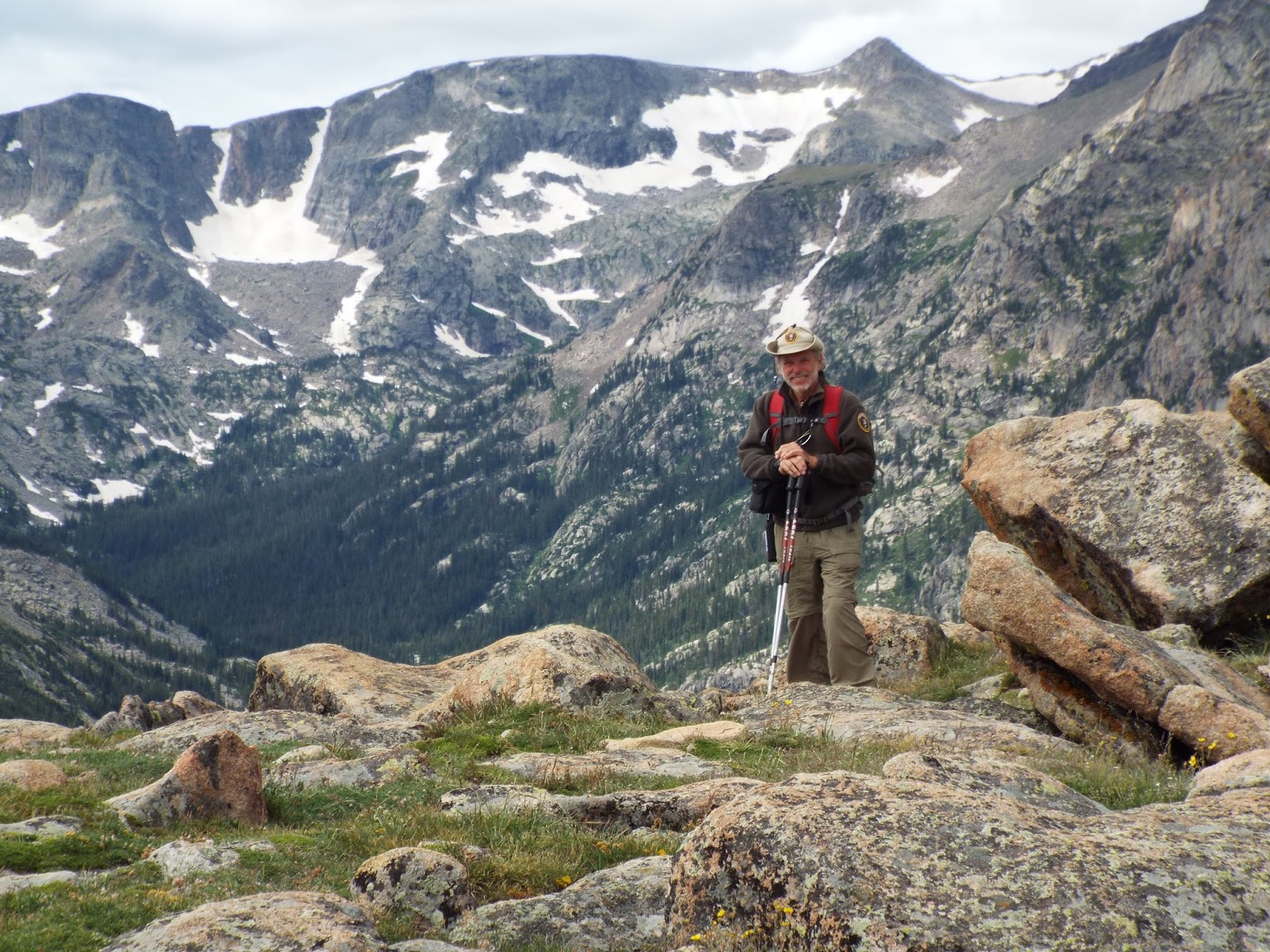
The third essential is good and proper equipment.  Pamela and I have seen people out on serious trails wearing sandals and flipflops. They think that just because the trail is frequently used and only 2.5 miles long (one way) that they don't need to be prepared. In my blog about running across the Badlands (3) I told about a family that I found a little more than a mile from the trailhead without map or water, wearing tennis shoes and sandals. They were lost. Besides your backpack, never go out on any trail without proper clothing, good boots, bear spray and trail poles.  Dress for the weather and be prepared for a change. Unless you got a 50% discount, if you paid less than $100 for your boots you probably don't have good boots.  I also suggest getting your boots from a reputable outfitter. They should know how to fit them as well as have the best boots in stock. If you are in Bear country, bear spray should be worn either on the hip or on a back-pack strap going over your chest. It should always be quickly and easily accessible. There is a story we tell visitors about the man who put his bear spray in his back pack, put the pack down to step off the trail and pee . . . . well, you can guess what happened. People laugh but it isn't really funny.  Even when I'm in the campground my bear spray hangs from my hip.  You will notice in the picture that I am carrying trail poles and wearing gaiters.
I believe that one should never do trails without poles. If you look at pictures of international ultra trail runners (50-100+ miles) you will notice that they always use  trail poles. Poles provide safety and stability.  The gaiters are optional but I always wear them because they protect my legs from underbrush and keep dirt and debris out of my boots as well as being beneficial if there is snow.

III.  Now that you're properly prepared and outfitted there is one other thing you should know before you hit the trail - wildlife.  Glacier National Park rules say to stay 100 yards away from bears and mountain lions and 25 yards from everything else.  Since the animals don't know the rules, it's up to you to try to keep the rules.  My grandson, Kieran, and I were approached by a Mountain Goat billy on Mt Oberlin. Kieran said, "we're closer than 25 yards."  All I could say was "we do our best."  I've also ended up close enough to a bear to smack it on the rump, but I didn't get that close on purpose. Sometimes it happens.  The big thing to remember is that the closer you are the more you stress the animal. Try to give them plenty of room. You still get a good experience, modern cameras can do marvels, and you and the animal will part friends.  Make plenty of noise as you hike. DO NOT BE QUIET.  The only people to be attacked by a bear while we were at Glacier in 2015 were two Rangers. They were going up the side of a mountain. There was a strong and very cold head wind, so they had their heads down to keep warm and weren't making any noise. No animal ahead of them was going to smell or hear them. They suddenly found themselves between a bear and her cub.  She knocked one of them down and threw the other up against the side of the mountain. She then took her cub and left. One of them got a cut. Point is, all animals will generally keep their distance from humans and they almost always smell and hear us long before we're in sight. The only exception is the Mountain Lion who is always in predator mode. So be sure to make enough noise especially if you are hiking into the wind. If you find the carcass of an animal on which another animal has been feeding, you are wisest to retreat from the areas as quickly as possible without running.  If you come upon fresh bear or mountain lion skat or indicators of the animal being there recently like the ground clawed up where the Grizzly has been digging Glacier Lilies, you want to seriously consider turning back. All National Parks in bear country have materials to learn about how to safely hike in bear country. Glacier hands a flyer out at the gate. Review such materials before you go hiking.  At Glacier, and probably also in other bear country parks, all staff are required to attend "bear school" ever two years. When you spend as much time as we do in the wilds, you're going to encounter most of the animals. Staff are always happy to answer any questions you might have about the educational flyers.

It may seem like a lot of trouble, but you can make the preparation for a hike in the wilderness an enjoyable experience in itself.  It really is harder to explain it than do it, but even if that weren't true it could mean the difference between having a marvelous adventure or a disastrous experience.  If you take the time to do proper preparation right from the start you will find that it takes less time every time you do it. Nevertheless I still carry a checklist. Complacency spells disaster.

I hope that this primer has given you some ideas, maybe raised questions that you need to ask, and encourages you to go into the wilderness prepared. I promise, it will be a lot more fun.

Good hiking. I wish you a most magnificent adventure!!


(1)  http://oldconservationist.blogspot.com/2015/11/looking-out-window.html
(2)  http://www.trimbleoutdoors.com/
(3) http://oldconservationist.blogspot.com/2015/11/running-badlands.html


Sunday, January 3, 2016

Life in Northwest Montana

Flathead County is the second largest county in the State of Montana. It has a population of 94,924 people living in an area of 5,255 square miles. (That's 18 people per square mile.)   Part of Glacier National Park lies in Flathead County including our home from May to September.

While there are many people we love in the east, and there is lots of beautiful country in the east, Pamela and I must admit that we're happiest when we're at Glacier.  We start to get a bit giddy when we first see the Rocky Mts in the distance.  That's when we start singing John Denver songs about the Rocky Mountains and Montana. By the time we turn north from Missoula we are sitting on the edge of our seats. When we see the sign for West Glacier we know that we're almost home.
The view from our campsite at Sprague Creek
For the first half of the season we live and work at Sprague Creek, about 11 miles into the park. We would love to stay at Sprague Creek for the entire season but the couple who have the other half would like to have our half.  For the first 12 weeks we live along the shore of Lake McDonald and take care of the 25 site campground that is 95% tent camping - no trailers or big RVs allowed. We have no internet, telephone or television. Even the satellite companies can't provide services. Firstly we're so far north that we can't aim a dish at the satellite without hitting a mountain. Secondly, even if we could around the mountains the forest canopy is so dense that nothing penetrates. We love it!

Tourist area of West Glacier
We try to leave the park no more than once or twice a week.  We have a Sunday morning breakfast with fellow hosts at a restaurant in West Glacier.  The most part of West Glacier, population 233, doesn't open until Memorial Day. The old village, originally named Belton, is open year around.  We will do our laundry when we're "in town" for Sunday breakfast. When we go shopping, need a vet or other services, we go to Columbia Falls, population 4,796. It is about 45 miles from us and is the closest of the three "big" towns in the area - Columbia Falls, Whitefish and Kalispell. There is a small community of Hungry Horse (population 826) where there is a grocery store, but it is very limited.

Columbia Falls
Actually Columbia Falls has two nice grocery stores where we can get just about anything we want.  Well, they don't have ocra. The vet who did Teddy's surgery in 2014 was in Columbia Falls and we really liked her. The town has three really good restaurants. One is actually a coffee shop - The Montana Coffee Company - and has one of the best offerings of vegetarian entrees anywhere.

If we need to go to a large store to get tires, Home Depot, pieces for the trailer, a Walgreen pharmacy or camping equipment and supplies we go to Kalispell, the county seat. Kalispell is about 65 miles from us and has a population of 20,972 making it the 7th largest city in Montana. Actually Billings at 104,170 is the largest city in Montana and still only 58% the size of Evansville, IN.  Oh, yes, I have to admit that Kalispell has a Walmart, but we don't hold that against it.
Hungry Horse about 20-25 miles from us.

For things like books, a great bicycle shop and anything touristy the best place is Whitefish, a ski resort town of 6,649 people. It is also the location of our nearest Ram dealer and hospital.  Another tourist town is Big Fork near the north end of Flathead Lake. Flathead Lake is the largest lake in Montana. Big fork is where we go at least once a season to enjoy summer stock theater.

We like almost everyone we meet who lives here year around.  There are a lot of transplants. The population of the entire State of
Main Street, Whitefish, MT   
Montana is less than 1 million people. Few of our friends and colleagues are actually from the area. We do, however, know three Rangers who went to school together in the North Fork - the most remote of this remote area.  Among the rest the joke is -  first day here you see the sights. Second day here you see the realtor.

  When the lights go out at night there is no city's glow in the distance. There's nothing but the Milky Way or perhaps the Northern Lights.  Our nearest neighbors are bears and mule deer. We get along well with our neighbors. Yes, it's true. We live in one of the most remote areas left in the United States. Isn't that marvelous!?

Kalispell, MT. 


Northern lights over Lake McDonald. 

The Greatest "Job" in the world!

"Main St" Sprague Creek. 
Those readers who know and/or follow me have often heard me make two statements "it is so much fun it is hard to call it work," and "we are honored and proud to be a part of the National Park Service."

Sprague Creek Campground. 
Sprague Creek Campground is the only campground at Glacier where the hosts have to be up by a certain time to open a gate. Each morning we roll out of bed in time to open the gate by 7am.  Since we're up we go ahead and do our first rounds. From then until noon or 1pm we will be busy helping campers get off on their adventures, introducing ourselves to our guests, teaching new campers about camping in the wilderness, and answering a plethora of questions.  Technically it is work, and actually it can be hard work, but for us it is our "people fix". We spent a few weeks working at a large campground where we didn't have this concentrated contact with the campers and it was like withdrawal.

Sprague Creek is very much in demand. It is a first-come campground, so it is not uncommon for there to be people sitting in their cars any time after 6am watching for someone to leave. This means that we are usually full by noon.  Between being full - therefore no new arrivals - and the fact that almost all of our campers will spend their days hiking, biking, kayaking or other adventures, we are free to have our own adventure.
In a short while this area will be filled with cyclist biking
across the US and just having come from the mountain pass.
They sleep in hammocks, small tents or under tarps.

We return home around dinner time. This is when our campers are returning and will be having questions. We will "work" from around 5pm until time to close the gate at 9pm. Sometimes we are called out after 9pm but that's not very common.  Our average work day is 9 hours long, but, as I've so often said, it is so much fun that it is hard to call it work.

The reason that we don't usually get called out after 9pm is that most of the campers are asleep by then or shortly thereafter. When you get up early, hike or bike or kayak all day, you are usually ready for bed early as well.

Campers gathered to share their adventures at days end.
Because it is more primitive - no trailers or large RVs allowed - Sprague Creek is popular among those who want to get away, serious campers, and world travelers.  By the end of May we will have hosted people who refer to themselves as "travelers" from ten to twelve different countries. We had a young woman who left home after college at age 21 to travel before settling down. She was 35 years old, had hiked and camped on every continent except Antarctica and hadn't been home yet. We had a family from France who had cycled from New York, heading to Alaska, with their two young children.  Then there was the couple my age (almost 70) who had dipped their toes in the Atlantic in February, climbed on their bikes, and were camping with us in May.
Sometimes it's just nice to sit and read. 

Pamela loves to teach the children and the children love her. When she takes them around the campground on mini-nature hikes there are always a few adults following along. Educating and making the campers' experience as profound as possible is one of our goals.  We also get the opportunity to help a lot of new campers learn about how to enjoy life in the wilderness as well as help experienced campers and back-country enthusiast plan their next adventure.

Lastly, but very far from least, we play an important part in the preservation and conservation of the wilderness. We do this by helping campers enjoy their stay without doing un-repairable damage to the environment as well as teaching conservation and environmentally friendly ways to enjoy the wilderness around them. We help people understand why we have certain rules and how to interact with wildlife they encounter.  This is important when you have all sorts of wildlife, including bears, roam through your campground from time to time.

If you want the greatest "job" in the world, ... want to do a great service to your country and the environment, ... want to help people really see and enjoy the wonders of the wilderness, you really want to visit www.volunteer.gov and make an application to become a National Park Service volunteer.

ALSO VISIT ME AT  www.facebook.com/old.conservationist 


Can Pamela come out and play?

We had just opened the gate at 7am and were grabbing some breakfast before doing our morning rounds when there was a knock at the door.  I opened the door to find five little blonde girls (sisters) from Minnesota standing there. Almost in unison they asked "can Pamela come out and play?" 
Pamela with the education table she put together in 2014

You'd think that this would be an uncommon scenario ... but it isn't.  Pamela love the kids and the kids love Pamela.  She will frequently start out taking a couple of children on a nature walk around the campground and end up with several children and often some adults. After a nature walk she will send them on hunts around the campground to find and identify types of wildflowers or trees.  The five little blondes were ready and eager for more.  "Okay, Pamela," I teased, "you can go play with your friends."  Pamela helps the youngsters complete their Junior Ranger book and earn their Junior Ranger badge. An interpretive Ranger at one of the visitor centers will get the honor of swearing them in and making a big deal at the center. But we get the best part.  We get to actually watch them complete the program and sign-off on their book.  To have a young person hold an often crumpled Junior Ranger book and a pen up to you and ask "will you sign my book" is priceless.  To get to sign on the line "Ranger" is an honor we take very seriously. 

Pamela with our boss, Ranger Justin Racioppi 
No matter what your job description is with the National Park Service, it in some way relates to making the visitor's stay as meaningful and exciting as possible.  Our days are long.  We average a 9-10 hours day. But when this type of experience is a part of your day, those are the best 9-10 hours of the day. 

We never look at our watches and wonder when we'll be done for the day. To the contrary we look forward to answering the door and hearing "can Pamela come out to play?"  

HAPPY 100th ANNIVERSARY NATIONAL PARK SERVICE.

Try to express the extent our love and admiration for the National Park Service is a daunting task. 
This isn't the best picture of us, but look at those smiles!  
I started ultra trail running when I was 63 years old and was tragically widowed when I was 65.  I ran through mountains and deserts of our National Parks all across the country.  I have always loved the wilderness but for some reason I never thought of volunteering for the National Park Service. 
At the end of 2013 I met Pamela. We both love to run, hike, cycle, camp . . . anything and everything outdoors. Pamela had been a triathlete until severe arthritis stopped her.  She not only introduced me to vintage trailers for which I now have almost as much passion as does she, but she asked if I would consider volunteering at Glacier National Park. 

Today she still laughs at my first reaction.  Sure, I'd love to work at the park, but for that many months?  Well, if you've followed me on Facebook or many of my blogs you'll know that that was a silly question. We want more!  We are now in our fourth season at Glacier and can't get enough time there.  We were thinking of just knocking around the Rocky Mts this year after the Glacier season ends, but we knew what would really make us the happiest . . . yesterday we put in our application for another national park where we will work from the close of Glacier to the end of November (assuming that we get the job) and we're looking for a third place to work between that and when we return to Glacier in May.  If we're lucky, we'll get to work at Glacier and two other parks each year. 

2016 is the 100th Anniversary of the National Park Service and we can not express how proud we are of the Park Service and how honored we are to be allowed to be a part of it.  Putting on the volunteer khaki and brown uniform is one of the greatest feelings.  

To conserve the scenery and the natural and historic objects and the wildlife therein and to provide for the enjoyment of the same in such a manner and by such means as will leave them unimpaired for the enjoyment of future generations. 
                                                      National Park Service Organic Act, 1916  

HAPPY 100th ANNIVERSARY


Friday, January 1, 2016

Exploring Howe Ridge

Howe Ridge burning during Robert Fire of 2003
Taken from the east side of Lake McDonald
Howe Ridge on the west side of Glacier National Park's Lake McDonald was one of the hot spots of the infamous Robert file of 2003. The heat along this ridge was so intense that people standing on the east side of the lake, almost two miles from the ridge, had to seek cover.  In 2014, Pamela and I hiked the trail along the lake at the foot of the ridge through the burn area.  You couldn't call it pretty, but you had to admire natures way of recovering.  Actually, fire is a very important part of the cycle of life in the woods which humans have attempted to alter. But that's another story.

In July of 2015 one of the campground hosts at Fish Creek Campground had to leave suddenly. Fish Creek is a large campground and too much for one couple to maintain for almost two months that remained in the season.  Pamela and I volunteered to work at the campground while our boss' boss found someone who could finish the season. This was the first time that we had worked in this part of the park.  Sprague Creek, where we spend the first half of the season, is about 11 miles into the park. Most of our activity is between there and Logan Pass. We only venture to the south end of Lake McDonald when we have meetings, are visiting friends or need to get a telephone signal.

Map of Howe Ridge Trail (yellow) from satellite photo
In exploring our new territory my attention was drawn to the Howe Ridge Trail.  I knew that the southern trailhead was on the Inner-Camus Road, a dirt road that runs up to Polebridge but hasn't been totally open for many years. I knew that the entire trail was inside the Robert fire burn area. It would not be a tree-covered hike.  Despite what I thought I knew and what I thought I was prepared for, I was wrong.

The trailhead
Since we were living only about 2 miles from the trailhead, I decided not to drive. That was a good decision.  Even though you have to go very slowly along this section of the Inner Camus Road, I could have missed the sign and there was no parking area. If I didn't have my topographic map with me which told me where the trailhead should be, I could have missed it hiking. Had it really been that long since anyone hiked the Howe Ridge Trail?  Evidently. The Lake McDonald Trail, which can actually be seen in the above photo running along the lake, is easy to see on a satellite photo. Not so the Howe Ridge Trail.

Wildflowers were magnificent
It became evident that no one had been on this trail for a really long time when I found it difficult to follow the trail. The new growth that followed the fire had almost totally obscured the trail and at times I wasn't sure if I wasn't following a small animal run.  The only reason that I was confident that I was on the trail was that I'm confident of my topographic map skills and they said I was on the trail. Before starting a steep ascent to to the top of the 4,668 foot ridge of lateral moraine I passed through a heavy stand of saplings and wild flowers with the skeletons of burned trees around me. After about a half mile I was beginning the ascent. The trail ran along the side of the ridge, open and barren, with a panoramic view of the burn area opening up in all directions.

One thing to which I did give serious consideration was wildlife. Right across the valley is an area which is frequently closed because of Mountain Lion activity.  Up the road, just a short distance west and north is an area where you can almost always count on a bear.  I was on a trail that was so overgrown that I couldn't see more than a few yards in any direction until I got a couple of hundred feet up the side of the ridge. So I had to decide whether I wanted to hike that first half mile alone in such density. I didn't know that it would start opening up in about a half mile, so I decided if it didn't get better soon I'd scrub the hike.  I hiked along singing loudly. When I wasn't singing I would talk to brother and sister bear as though they were standing right there which they could have been without being seen.

It might be good to share with those of you who are new to my wilderness stories to know that I do have a lot of back-country experience. I remind my children that I'm adventuresome not foolhardy. Most of my previous solo back-country adventures had been ultra trail runs in the eastern mountains. The only reason that I had been doing the trail patrol - about 8-15 miles of trails a week - alone and so many solo hikes is because Pamela's knees were bone-on-bone.  She would have bi-lateral (both knees) complete knee replacement in December. Even when I'm doing a day hike of 10 miles or less, like this hike, I go prepared to be gone as long as it takes. That means carrying my 20 pound survival pack complete with survival kit, 4L of water, food and a number of emergency devices like ResQLink and SteriPen.  Actually you won't find me leaving a paved road without it. You don't have to be 50 miles from civilization to need such a pack.  You will also notice ice cleats hanging from the pack. They are always there. On June 23rd 2014 we had almost 30 inches of snow at elevations above 6,000 feet. Occasionally someone will tease me a bit because I always wear gaiters and use trail poles, but I've never been teased by anyone with real back-country experience.
The trail began to open as I
gained elevation. 

Looking northwest  
Even as the trail opened I continued to sing. By this time it just seemed the thing to do and I was enjoying it.  The only time I stopped was when I stopped to admire the view.  I had learned a lot about how a forest recovers after a fire but here I was seeing it in person. Granted it had been 12 years but the process was right before me. The wild flowers were thick. Following the growth of flowers and shrubs come the Lodgepole pines. The cones of the Lodgepole are pyriscent. They need fire to reproduce. The fire melts a resin that seals the cones and releases the seeds.  It is knowing that fire is a necessary and beneficial part of the cycle of life of a forest that makes this hike so enriching. I look out over the new growth and stand in awe of the power of nature.

I arrived at the  top of the ridge, 4,668 feet up  and 1,468 feet above where I started at the Fish Creek Campground.  After 12 years the shrubs and new growth were about my height. I had been anxious to see the view from the top of the ridge but, alas, all I could see was the new growth. The picture below was taken by climbing up on a large pile of fallen trees.

Lake McDonald from atop Howe Ridge
 The new growth at the top of the ridge was as thick as it was at the trailhead. I couldn't see a thing except the teenage Lodgepole pines and shrubs around me. The trail again became very narrow and overgrown. Not wishing to push my luck with the local inhabitants  I decided to turn back. Anyway, the next point to descend to the lake was 7 - 8 miles further down the trail and it was already mid-afternoon. I had indeed gone where no one had been for an exceptionally long time. It had been an enjoyable adventure.

On my way back to the Inner Camus Road I started singing as I came off the side of the ridge. I had not gone half the distance from the ridge to the road when I heard noise to my left. With the thickness of the undergrowth it would have been difficult for anything other than a snake - of which there are very few in the Rocky Mountains - to pass without making some noise. To me whatever was there sounded big. Perhaps I sounded big to them as well.  It was as though whatever was making the noise had also stopped to listen. There was silence when I stopped.

Osprey nest
"Friend bear," I said in a loud voice, "I'm just on my way back to the road. I'll continue on my way, if you don't mind, and leave you in peace."  Perhaps friend bear understood me, but the next thing I knew the sound was moving in the opposite direction of me. With a sigh of relief I walked back to the road, waved good-bye to friend bear and anyone else on the mountain who might have heard, and started the two mile hike home.

It had been an outstanding afternoon. I got to witness the process of restoration of a forest. I will definitely be going back to watch with wonder at the development of a new forest over the coming years. With a plethora of varieties of wildflowers, I spent a lot of time on the return trip taking pictures of wildflowers for Pamela's book.  As I hiked along I noticed an Osprey nest high on top of a burned lodge pole. This nest is a short distance, as the Osprey flies, from Lake McDonald.  The Osprey is a large raptor whose diet is fish and is sometimes called a Fish Hawk. As I crossed the almost dry Fish Creek I looked up at the dark threatening sky and hoped for rain. Unfortunately it did not come. We went well over three months with only 4 days of rain.  As I approached the entrance kiosk one of the rangers called a greeting. I stopped to share my adventure with them then made my way back to camp where Pamela and my grandson, Kieran, had been having their own adventure along Lake McDonald.

So often we seek out "beautiful" hikes.  But what is beauty?  There are many things and many places that, from a picture, we would label "not pretty" or even "ugly", but when experienced up-close-and-personal turn out to have their own beauty.  I think we are so geared to fear and hate fire that we do not see the magnificent and beautiful process of rejuvenation that is the result of a forest fire. I have learned in some of the wildlife and ecology classes I've taken that most of the burn areas that take the longest to recover are those where human's have tried to intervene.  In many areas a forest needs to burn every 50-80 years.  I guess that others share my fear; viz. that the general public will see the burn area as unsightly and visitation will drop until some pencil pusher decides to sell off the burned area. There is a magnificence, not beauty, but magnificence in watching a forest come to life after a fire. It is like watching a new birth.


Our 2015 stats

It's time again to look back at our activity during 2015. We didn't cover as much ground in 2015 as we did in 2014 but it wasn't because we weren't trying or getting tired and lazy. Quite the contrary. As Pamela said the other day "2015 was really a very physically demanding year for us."

In the spring of 2015 Willy got a complete exterior overhaul - opened all seams and replaced any bad wood,  new roof fixtures, paint job, etc. It was a physically demanding project which we're happy having done. The project kept Willy out of commission for over 2 months during a time we would have normally had him out camping at Land Between the Lakes or other similar primitive camping areas.  We also went on a cruise which kept us out of the woods for a couple of weeks, but that trip gave us time to snorkel and scuba.  Also in the spring Pamela's surgeon agreed to do the total knee replacements she had been wanting.  She didn't want to be recovering when we were heading toward Glacier so the bilateral knee replacement was done on Dec 7th. Pamela now has two brand new knees. She has had one set back. A hematoma developed for some unknown reason on her right knee cap keeping her from doing her rehab therapy.  So the fact that she climbed a mountain in July with bone-on-bone knees just shows how strong and determined a woman she is.

In any case, as I've done just for the fun of it in the past two years, here's a summary of our adventures and activity in 2015.
Pamela near summit of Mt Oberlin

(1) Overall we traveled in excess of 9,580 miles with Willy, camping for >90 consecutive nights and a total of 116 nights.
(2) We only biked about 90 miles or so this year. Again, it wasn't our idea. Because of the unseasonably warm winter at Glacier the Going-to-the-Sun Road, which is generally not open to auto traffic until July, was open by mid-June cutting our cycling time almost in half. We did probably do another 15-20 miles around Fish Creek and during our trips to Raccoon Lake in October.
(3) We kayaked about 10 miles this year. You should have seen poor Pamela trying to get in and out of the kayak with her bad knees. By November we were pretty much pulling her up on shore in the kayak and rolling her out. Her knees were hardly working by then. I took grandson, Kieran, on Bowman Lake. Pamela and my daughter, Kelly, spent a lot of time on Lake McDonald with the two of us spending a great day on the Kentucky River in early November.
(4)  I hiked in excess of 150 miles this year.  A high percentage of that was our trail patrol. Pamela, of course, could not go much of the time because of her knees. She did a couple of shorter trails (<5 miles) in May and climbed Mt Oberlin in July. She's anxious to get back on the trail in 2016 with her new knees.
(5) We went diving and/or snorkeling in Hopkinsville, KY, Panama City Beach, the Bahamas and Lost Quay (a private island belonging to the cruise line).  Pamela is working on her open water certification. You might remember that I finished my Master Diver certification in Aug 2014, but that doesn't qualify me to supervise Pamela on a dive.

All in all 2015 was really a great year for us. Evansville is now home base and we're anxiously looking forward to being 100% Walden Pond Full-timers by the first of May when we head to Glacier. From there it's wherever our fancy takes us. It's going to be great!

Hope you all had a wonderful, exciting, adventuresome and productive 2015 and we wish you a very super wonderful, exciting, adventuresome 2016.

IN MEMORIAL:  2015 was not without loss.  Cubby, one of the G-3 (Glacier Three - the three small dogs that traveled and camped with us), died the day after Thanksgiving.  Fittingly he passed away while we were on the road. He loved to travel with us.  We miss him very much.

Cubby loved to sit on my lap as we traveled.
Usually he was looking forward as though watching the road.


Cubby at Glacier wearing his "uniform" jacket.